
HIGH PLAINS LAKE TRAIL
About The Area
As the largest town in northwest Kansas, Hays is the gateway to the High Plains and it serves as the primary entry point to the High Plains Lakes Trail. Hays is a town rich in the history of the Old West. Characters such as Buffalo Bill Cody, Calamity Jane, George Custer, and Wild Bill Hickok all spent time in Hays. Below are three of the most popular birding sites in Hays. The two birding areas on the south side of town are on land directly linked to the era of the Wild West. They are both on land that was once part of the Fort Hays Military Reservation, established to protect people traveling by stagecoach on the Butterfield Overland Dispatch.
Frontier Park
HIGH PLAINS LAKE TRAIL
About The Area
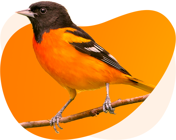
This 89-acre city park features several walking trails including the well-marked Big Creek Nature Trail that winds along the banks of Big Creek. Large shade trees are found throughout the park and the creek has small waterfalls making this a pleasant and picturesque place to birdwatch. This riparian habitat along the creek is one of the best places to see nesting species such as Wood Duck, Belted Kingfisher, Great Crested Flycatcher, Warbling Vireo, and Baltimore Oriole. It is also an excellent location to bird during spring migration. Gnatcatchers, vireos, Swainson’s and Hermit Thrushes, and numerous species of warblers, including such seldom seen species as Canada and Blackburnian. Both Black-headed and Rose-breasted Grosbeaks could add color to your birding experience here. Winter birding can produce Yellow-bellied Sapsucker, Black-capped Chickadee, Red and White-breasted Nuthatch, Brown Creeper, Winter Wren and Pine Siskins.
Agriculture Research Center
HIGH PLAINS LAKE TRAIL
About The Area
Although this is a Kansas State University Research Station, birders are welcome to drive or walk around the buildings and grounds to birdwatch among the beautiful landscaping, pine trees, and shrubs. However, be careful not to venture into the research plots and use discretion when birding around the two residences. An impressive tree-lined drive greets birders and may hold interesting birds, especially in winter. The plantings of pines and arborvitae make this a good location to see wintering species such as Yellow-bellied Sapsucker, Red-breasted Nuthatch, Townsend’s Solitaire, and Red Crossbills. If you do encounter crossbills pay attention to their calls. At least four distinct types of Red Crossbills have been recorded here. At times the numbers of wintering American Robins and Cedar Waxwings may number in hundreds or occasionally even thousands. On one occasion a Bohemian Waxwing was seen here. As one might expect with the presence of mature pine trees, Pine Warblers have been sighted here during migration.
Vineyard Park Nature Area
HIGH PLAINS LAKE TRAIL
About The Area
Vineyard Park is another Hays city park, but it offers a much different birding experience than Frontier Park. Whereas Frontier Park is characterized by large trees and a forested riparian strip along Big Creek, this park features a scenic 1.1-mile nature trail through wetlands, prairies, thickets and smaller scattered trees. Vineyard Park also has a fishing pond which is visited by geese and ducks. The birds seen here reflect those habitat differences with waterfowl and grassland species more likely seen here than at the aforementioned sites.
HIGH PLAINS LAKE TRAIL
About The Area
HIGH PLAINS LAKE TRAIL
About The Area
HIGH PLAINS LAKE TRAIL
About The Area
HIGH PLAINS LAKE TRAIL
About The Area
The north shore of the 3,780-acre reservoir is dominated by Webster State Park. The state park has six campgrounds on the north shore and one campground on the south shore. These campgrounds offer excellent vantage points for scanning the water for gulls and waterfowl. Valid Kansas State Park entrance permits are required year-round for this area. A good variety of gulls have been reported from here, including Glaucous, Iceland, Lesser Black-backed, Little, Laughing, and California, along with the more common gull species. Shorebirds can be abundant during migration when mudflats are available. At least 32 species of shorebirds have been identified here. Away from the lake, the wooded areas attract good numbers of migrating songbirds. The south shore offers nice riparian areas to check for songbirds. Also, depending on water levels, the south shore often produces the greatest numbers of shorebirds. Other species to look for in the area include Greater Prairie Chicken, Black-billed Magpie and an abundance of fall and winter sparrows.
HIGH PLAINS LAKE TRAIL
About The Area
This small 64-acre lake can be surprisingly productive for such a small body of water. In fact, over 200 species have been recorded here. During migration, waterfowl can show up in good numbers. Black-bellied Whistling Duck, Greater Scaup and White-winged Scoter are some of the uncommon ducks which have been reported here. Depending on the water level and presence of mud flats shorebirds may be present. Almost 30 species of shorebirds have been seen here, including both Hudsonian and Marbled Godwits, Long-billed and Short-billed Dowitchers and Wilson’s and Red-necked Phalaropes. Both Loggerhead and Northern Shrikes have occurred here too. In the evenings you might hear the screech-owls that sometimes nest here.
HIGH PLAINS LAKE TRAIL
About The Area
A road on each side of the lake makes scanning the entire lake easy. With little cover for birds to hide you can immediately tell if waterfowl are present. This lake often attracts good numbers of both diving and dabbling ducks in migration. Check the small marshy area just to the north of the lake for any marsh birds. In spring and fall if mudflats are present check for shorebirds. At least 17 species of shorebirds have been seen here over the years. For songbirds check the walking path to the east of the lake which winds its way through a grove of trees.