

TOWN AND COUNTRY TRAIL
About The Area
Nestled in the Flint Hills, El Dorado Reservoir offers a variety of habitats, providing year-round birding opportunities. The dominant habitat around the lake is tallgrass prairie where you can find Dickcissels, Upland Sandpipers, Common Nighthawks and other prairie species. In early spring you might even hear Greater Prairie Chickens booming or the flight calls of Smith’s Longspurs overhead. The lake itself is best during the fall and winter months, when recreation is light compared with the warmer months. Look for scoters among the many waterfowl species. This lake is popular for Bald Eagle viewing with the many snags in the upper part of the lake providing places for eagles to perch. In summer Tree Swallows and Prothonotory Warblers can nest in these snags. As with all large lakes, a spotting scope will come in handy to survey this reservoir. Good vantage points include the boat ramp at the northwest end of the dam, the Boulder Bluff Camping Area, the southeast end of the dam, the Shady Creek Marina and Fisherman’s Point on Bluestem Point. During breeding season listen for Henslow’s Sparrow along NE Teter Rd, the road into Bluestem Point (especially near the entrance) and the Shady Creek Access road west of Hwy 177. Also along Teter Rd, look for Upland Sandpiper, Scissor-tailed Flycatcher and Grasshopper Sparrow. Of several trails in the park the best is the Teter Nature Trail. Near the parking area, look for Bell’s Vireo and Gray Catbird. The trail descends into bottomland forest that includes Louisiana Waterthrush, Prothonotary Warbler Northern Parula and Kentucky Warbler in addition to the usual woodland species. The entire Walnut River Area below the dam is excellent during migration, especially the Tall Oak campground.
TOWN AND COUNTRY TRAIL
About The Area
The 71st Street Canoe Launch site is a surprising oasis in the Wichita area. The boat ramp is the reason for this park, but miles of hiking opportunities exist which traverse through riparian woodlands, river sandbars, and brushy areas. The main attractions here are resident Pileated Woodpeckers, nesting Fish Crows and Painted Buntings (May-August). Other summer species include Blue Grosbeak, Northern Parula, Chuck-wills-widow, White-eyed Vireo, and Summer Tanager. Winter brings large numbers of sparrows to the brushy areas in addition to the typical woodland birds. Bald Eagles and Red-shouldered Hawks have nested nearby in recent years, and can be found during anytime of the year. Interesting birds seen here include Western Grebe, White-winged Dove, Golden-winged Warbler, Lazuli Bunting, Yellow-breasted Chat, and Purple Finch. There are two maintained trails; one north of the parking area and one south. Both can offer birding opportunities, especially the one to the south. These are usually quiet, but can hold migrant songbirds on a good day. You can also walk on the dike along the river both north and south for several miles. Be especially alert for birds in the plum thickets along the dikes, and listen for buntings singing from the edges of the woods and open trees. As one walks south for about a mile, you can follow the dike as it curves along the Big Ditch or continue along the river straight south onto dirt trails into the woods. White-eyed Vireos nest in these woods and other woodland species may be encountered on a hike all the way out to the convergence of the Arkansas River and Big Ditch. If you continue on the dike things begin to open up. A hike down to the water in the Big Ditch here is likely to produce waterfowl, shorebirds, and waders in season. Be aware that these hiking trails are all out and back walks and that this location is a popular place for off-road vehicles on weekend afternoons.
TOWN AND COUNTRY TRAIL
About The Area
This 640-acre park includes 1.5 miles of riparian woodland, grasslands, and old shelterbelts that were planted when it was farmland. The name of this park is somewhat misleading as woody vegetation has invaded much of what was formerly prairie. These woodlands provide habitat for a variety of woodpeckers, wrens, and Great Horned Owls. Usually the most productive birding is on the trails closest to the creek, but interesting birds can be seen anywhere here. The woods along the creek have matured enough that an array of birds of eastern woodlands can be found throughout the summer, including Pileated Woodpecker, Red-eyed Vireo and Wood Thrush. Some of the rarer birds found at this park have been Common Poorwill, Whip-poor-will, Rock Wren, and Green-tailed Towhees.
TOWN AND COUNTRY TRAIL
About The Area
This large reservoir is formed by a large dam on the North Fork of the Ninnescah River. It normally covers about 9,500 surface acres and is surrounded by 5,240 acres of public wildlife area and 1,913 acres of state park. The lake is a popular recreation resource and is heavily used for boating, fishing, hunting, camping and picnicking, especially during the summer months. The State Park has units on both the east and west sides of the lake. On the west side, the Spring Creek Nature Trail near the Smarsh Campground provides a nice place for a short birdwatching walk. The State Park camping area on the west shore has large trees that attract nesting Red-headed Woodpeckers, Mississippi Kites, and Baltimore Orioles. Both State Park units offer places from which you can scan the lake. Although closed in the winter, another good birding spot is the Red Bluffs area on the east side of the lake. The DeWeese Park farther north on the east side is excellent for songbirds, including nesting Rose-breasted Grosbeaks. Birding at the lake is best from fall through spring, when other users of the lake are not present in great numbers. A spotting scope is suggested when trying to identify birds far out on the lake. In October, concentrations of Franklin’s Gulls have been recorded in the hundreds of thousands of birds. Large flocks of White Pelicans, Double-crested Cormorants and many species of waterfowl are often seen. Sometimes shorebirds can be found at the water’s edge at the base of the dam. Some of the many rare birds which have been seen at Cheney Lake include Yellow-billed and Pacific Loons, Red-necked, Western, and Clark’s Grebes; Brown Pelican; Black-headed, Little, Laughing, Glaucous, and Iceland Gulls.
About The Area
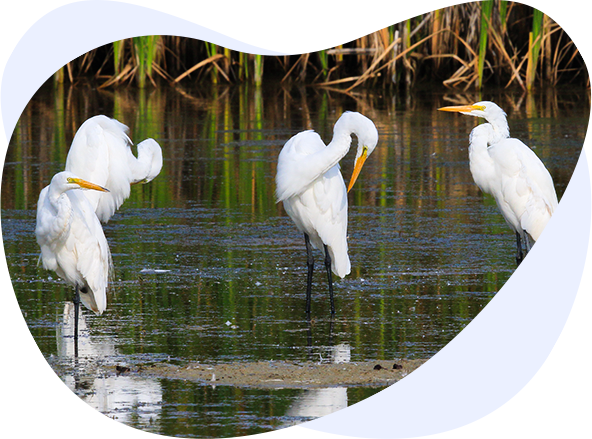
Pracht Wetlands Park is a relatively new and innovative 90-acre park set aside to preserve scarce wetland habitat. Its modern design incorporates an artistic approach to immersing visitors into the world of wetlands. In fact, the primary goal of the planners was to “employ art to bring people into the wetland in a way that doesn’t negatively affect the wetlands and wildlife.” A paved path and elevated walkway allow access into the marsh. Two “public art” blinds provide opportunities for close up observation and photography. Interpretive panels focusing on the many benefits of wetlands educate and inspire visitors. Like the site’s public art, the birds here are aesthetically pleasing and add color to your world. Pracht Wetlands Park is a great place close to the city to see wading birds such as Great and Snowy Egrets and Little Blue and Green Herons. During late April and early May you can find a good assortment of shorebirds. Around the periphery of the wetlands, nesting birds include Ring-necked Pheasant, Bell’s Vireos, Brown Thrashers, Dickcissels, Goldfinches, and both Eastern and Western Kingbirds. During winter a good this a good location for Harris’s, White-crowned, Tree and Song Sparrows.
TOWN AND COUNTRY TRAIL
About The Area
Oak Park preserves the oldest mature hardwood forest in Wichita. This park is one of the best places to find migratory songbirds in the area. Thirty-five species of warblers have been seen in the park, mostly in the first two weeks of May. These have included multiple records of warbler species which are rare anywhere in Kansas, including Black-throated Blue, Cerulean, Connecticut and MacGillivray’s. Moreover, Oak Park probably has produced more records of Worm-eating Warbler than any other location in the entire state! All of the eastern Empidonax flycatchers have been recorded. Vireos are numerous and some of the more unusual species like White-eyed, Yellow-throated and Philadelphia should be looked for in early May. Summer Tanager is annual in spring and Scarlet Tanager is seen in most years. Most of these species also can be seen during fall migration, but in much smaller numbers and over a much more extended period. Besides the warblers for which it is most famous, some of other finds at Oak Park have been Veery, Lazuli Bunting (nearly annual), Black-headed Grosbeak, Painted Bunting, Plumbeous Vireo and Western Tanager. In summer and winter you can expect typical woodland bird species of the eastern forests. Cooper’s Hawks and Yellow-crowned Night-Herons have nested here.
TOWN AND COUNTRY TRAIL
About The Area
A broad swath of open woodlands and thickets extends for almost a mile between the golf course and the Arkansas River. Trails exist throughout the woods. The brushy and wooded areas are on stabilized sand dunes, so this park is more rolling than in most parts of Wichita. During migration an excellent variety of birds can be found. Along Amidon Street on the east edge of the park is a large stand of pine trees. During invasion winters, good numbers of Red-breasted Nuthatches, Red Crossbills, Pine Siskins and other species are found in these pines. Eight species of herons occur in Wichita and Sim Park provides a good place to look them as they feed along the river. Some of the notable birds which have been found in Sim Park over the years include Long-eared Owl, Lewis’s Woodpecker, Pygmy Nuthatch, and a good variety of warbler species.